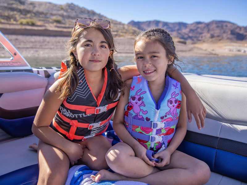
We were running full throttle into the West River when my daughter asked an innocent question.
“Daddy, how do you know where to go?”
I love moments like these. Not just because my kids wanted to learn, but because for once I knew the answer. I throttled back so everyone could hear.
“Do you see that red marker, the triangular one?” I said.
“Yes.”
“Well, I just make sure to keep the red markers on my right – or starboard as we say out here on the water.”
“Umm, okay.”
We turned up the Rhode River and dropped anchor at a little sand island. After a couple hours of swimming and sand-castling, we started toward home. That’s when my other daughter piped up. She’s the skeptical one.
“Daddy, the red sign is on the left,” she said.
“Also known as ‘port,’” teased my other daughter, making air quotes with her fingers.
“Are we going to crash?” added the skeptical one.
“Well, no,” I said, easing back the throttle again. Professor Dad cleared his throat. “You see, right now we’re going out toward the ocean, so instead of keeping the red buoys on the right, we keep them on our left.
“There’s an easy mnemonic for that. Do you girls know what a mnemonic is?”
Eye rolls all around; daggers from the wife. I kept talking.
“Old sailors have a saying, ‘Red, right, returning.’ That means you always keep the red markers on your right – or starboard – when you’re returning to port.”
“But we’re on our way home now,” said the skeptical one, who also happens to be smart as a whip. “That means we’re returning, so shouldn’t the red markers be on the right?”
“Daddy slow down,” said the other daughter, who is just as smart but more cautious.
“We are going home but we’re not ‘returning,’” my air quotes this time. “According to the Navigation Rules, returning just means you’re headed from a larger body of water toward a port.
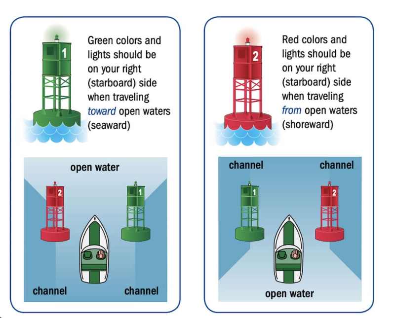
So ‘red right returning’ usually applies when you’re headed inland from a bigger body of water. And if you’re headed out toward the ocean like we are now – even if you’re going home – you keep the reds to the left and greens to the right.
“There’s another old sailors’ saying for that . . . do you know what it is?”
More eye rolls.
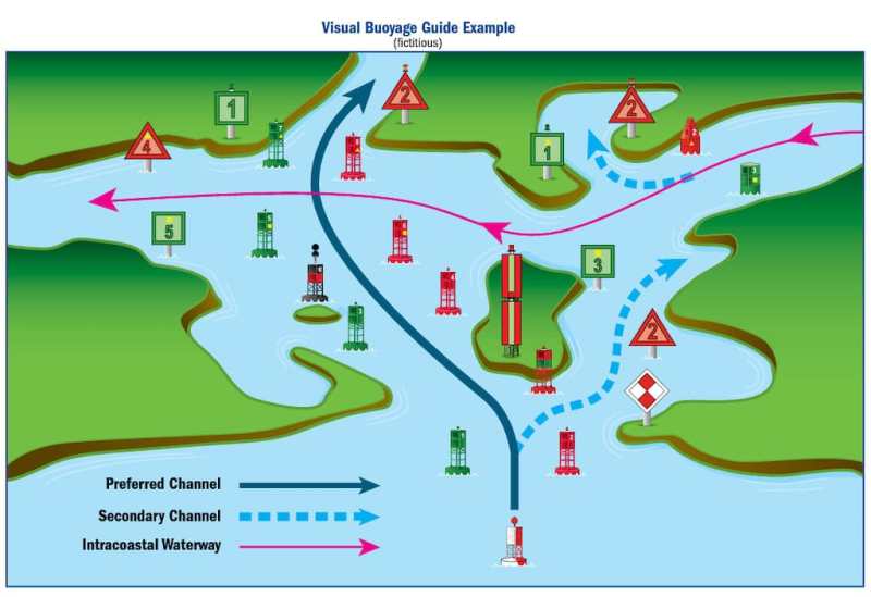
“Red and green, stay in between. How easy is that? No matter which direction you’re going, when two channel markers are next to each other, the channel is between them. Now, markers aren’t always placed side-by-side – in most waterways they alternate – but you can often see the path between them.”
I kept it at a slow cruise all the way home, and the girls kept the questions coming.
Why are the green ones squares and the red ones triangles?
Great question. Imagine you’re out on the water early in the morning or late in the day, and you’re looking into the sun or there’s just not enough light to make out the color. In those cases, you can tell whether a marker is red or green simply by its shape.
Do the floating markers mean the same thing as the fixed ones?
Yes, they follow the same color scheme even though they come in different shapes and sizes. The big ones are called buoys, and often have lights on them that flash in a certain pattern. The patterns are marked on navigation charts, so boaters can identify them at night.
The smaller floating markers have special shapes. The green ones have a flat top and are called ‘cans.’ The red ones have a cone-shaped top. They’re called nuns.
Why are they called nuns?
I have no idea.
What do the numbers mean?
Great question. Did you notice the red markers have odd numbers, and the green ones have even numbers? The numbered markers are shown on nautical charts and digital chart-plotters, so if you can read the number it’s easy to pinpoint your location on the chart.
Another really useful thing about the numbers is they increase as you go inland. So if you’re wondering whether or not you’re “returning,” just check the numbers. If they’re going up, that means you’re returning and you should keep the reds to your right.
What about those little orange and white buoys?
Those are informational and regulatory aids. Some of them mark hazards, such as shoals or swimming areas, and others alert boaters to rules such as speed limits and no-wake zones.
If the buoy marks a hazard, it will have an orange diamond shape on it. It may also have writing describing the type of danger, such as ‘rock. Sometimes they just say ‘danger.’
The rules markers have an orange circle with black text – often a number indicating the speed limit. An orange diamond with a cross inside marks an exclusion zone, while orange squares are for informational buoys. They provide helpful information such as directions, distances and locations.
Are there other colors and shapes?
Yes, navigational aids come in many different colors, patterns and shapes, and they all mean something to knowledgeable boaters. For example, yellow markers indicate special areas or features such as anchoring zones, traffic separation or underwater cables or pipelines. Red-and-white buoys are “safe water marks” – they are used to mark offshore approach points, or the middle of a wide channel.
You might also see markers that are both red and green. These are called preferred channel aids, and they’re not quite as confusing as they seem at first. The shape and top color indicate the preferred, or main channel. The bottom color marks a secondary channel. So let’s say you’re returning – just keep the triangular markers with red on the top to your right, and you’ll stay in the main channel. If you keep the same marker to your left, you’ll be in the secondary channel. Fun fact: instead of numbers, preferred channel aids have a letter designation.
Okay, but what if you’re cruising the Intracoastal Waterway?
The ICW is a special case. Because there are multiple entrances to the ICW up and down the coast, it can be hard to know whether you’re coming or going. Luckily, there’s a rule for that too.
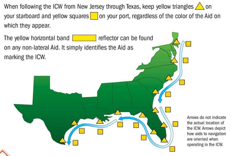
On the ICW the red markers are on the continental side of the channel, while the green ones are on the seaward side. Or thinking of it another way, if you’re travelling clockwise – meaning in the general direction from New Jersey to Texas – you’re “returning,” and should keep the mainland, and the red buoys, on your right. If you’re Jersey-bound, or just headed that way, keep the green markers on your right.
Of course, that’s when you’re in the ICW proper. Sometimes, because the ICW crosses and joins other established waterways, the lateral buoys change. For example, colored aids to navigation “swap sides” three times near the Savannah River intersection. That’s why the Coast Guard gives the navigation aids on the ICW an extra symbol—a reflective yellow triangle or square—in addition to its regular number, shape, and color. These shapes are specific to the ICW. When following the ICW, you should navigate by the yellow symbols; otherwise, navigate by the color of the markers itself.
Do the markers mean the same thing everywhere you go?
For the most part. ‘Red right returning’ is pretty universal, both in the United States and around the world, but there are some regional differences. We’ve already talked about the ICW’s special markers. Another region that uses a slightly different convention is the so-called Western Rivers of the United States – that’s the Mississippi and its tributaries above Baton Rouge, and several other rivers that flow into the Gulf of Mexico. For example, the navigation aids on the Western Rivers are not numbered sequentially, although they do usually show a mile marker (statute miles, in case you’re studying for trivia night). On the rivers, you keep the markers on the right when going upstream. That makes sense, as traveling upstream generally means you’re proceeding inland. It’s easy enough to remember, too, even if ‘red right upstream’ doesn’t exactly roll off the tongue.
Where can I learn more?
The U.S. Coast Guard’s Aids to Navigation page is the go-to reference and a great place to start. And taking a boating class, either online or in person, is a fast-track to Professor Dad status. They may laugh and roll their eyes, but sharing and practicing boating knowledge is the best way to keep you and your family safe on the water.
The U.S. Coast Guard is asking all boat owners and operators to help reduce fatalities, injuries, property damage, and associated healthcare costs related to recreational boating accidents by taking personal responsibility for their own safety and the safety of their passengers. Essential steps include: wearing a life jacket at all times and requiring passengers to do the same; never boating under the influence (BUI); successfully completing a boating safety course; and getting a Vessel Safety Check (VSC) annually from local U.S. Coast Guard Auxiliary, United States Power Squadrons®, or your state boating agency’s Vessel Examiners. The U.S. Coast Guard reminds all boaters to “Boat Responsibly!” For more tips on boating safety, visit uscgboating.org.


